|
Andrea and I and our kids will be camping on our land this weekend, and you are all invited! We intend to survey potential home sites and to pray over the land. We will be heading out Saturday morning and returning Monday.
If you want to come camping with us (or just to hang out for a while), here are some important things you need to know... and directions.
First, it takes about 50 minutes from central Tucson to our land. It's mostly Interstate but the last 15-20 minutes are on a well-maintained dirt road. It's OK for passenger cars but drive carefully because it has rough spots and loose rocks. The site is remote and cell-phone reception is poor or non-existent. We have neighbors with phones in the event of an emergency.
Second, there is no water or electricity on our property and no prepared campsites. I am setting up an enclosed sawdust toilet on Friday and clearing an area for tent camping (call me if you want to help). If you intend to stay overnight, be aware that there may be a little extra work involved to clear a spot for a tent. We will have the proper tools for this. Bring your own food and water (very important). We'll have a little to share but not much. There is a gas station with a convenience store 20 minutes drive from the homestead.
Third, since we do not have a cleared parking area off the road, we recommend overnighters to carpool if possible.
Now, if you are as yet undeterred (we hope not!), here's how to find us!
The easy way to find us is to come to our house on Saturday morning at 9am, then follow us.
Or you can find our land yourself and come at your own pace. Following are directions from Speedway and Kolb with a map.
Note: Do not use Google Maps or MapQuest or any other online map. For one thing we don't have an address, and for another thing they are wrong once you get into our neighborhood. Use the map I prepared instead.
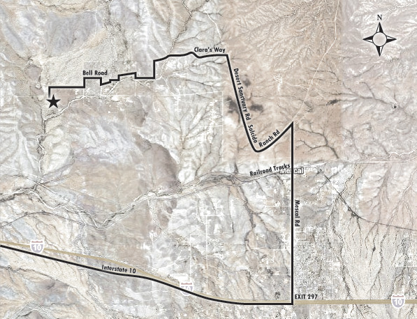
DIRECTIONS TO THE MCCULLEY HOMESTEAD
- Take Kolb south to I-10 (about 9 miles from Speedway).
- Get on I-10 East toward El Paso.
- Take I-10 about 26 miles to Exit 297 (J-6 Ranch and Mescal). You can follow the map below from here.
- Exit I-10 and take Mescal Road north. The convenience store is on your right just north of the freeway. This is a good place to stop if you need to pick up any last-minute items, get gas, or take your last chance to use a flush toilet.
- Continue on Mescal Road north, past the railroad tracks, to Salcido Ranch Road. This is about 2 1/2 miles.
- Take a sharp left onto Salcido Ranch Road, which may also be called Desert Sanctuary Road. The pavement ends at this point.
- Look for a street sign for Clara's Way on your left. This is about a mile and a half.
- Turn left onto Clara's Way and take that more or less to our property. At some point that is not clear to us, Clara's Way becomes Bell Road. There are a few turns but none of the roads are labeled; follow the attached map as best you can. (It's not as difficult as it sounds; whenever you come to an intersection, turn right.) We are near the end of the road, about 3 miles. The property immediately to the north of us has the address 13611 S Bell Rd.
For those of you with a GPS, the northwest corner of our property is approximately at the coordinates N 32 00' 357" W 110 29' 659".
|